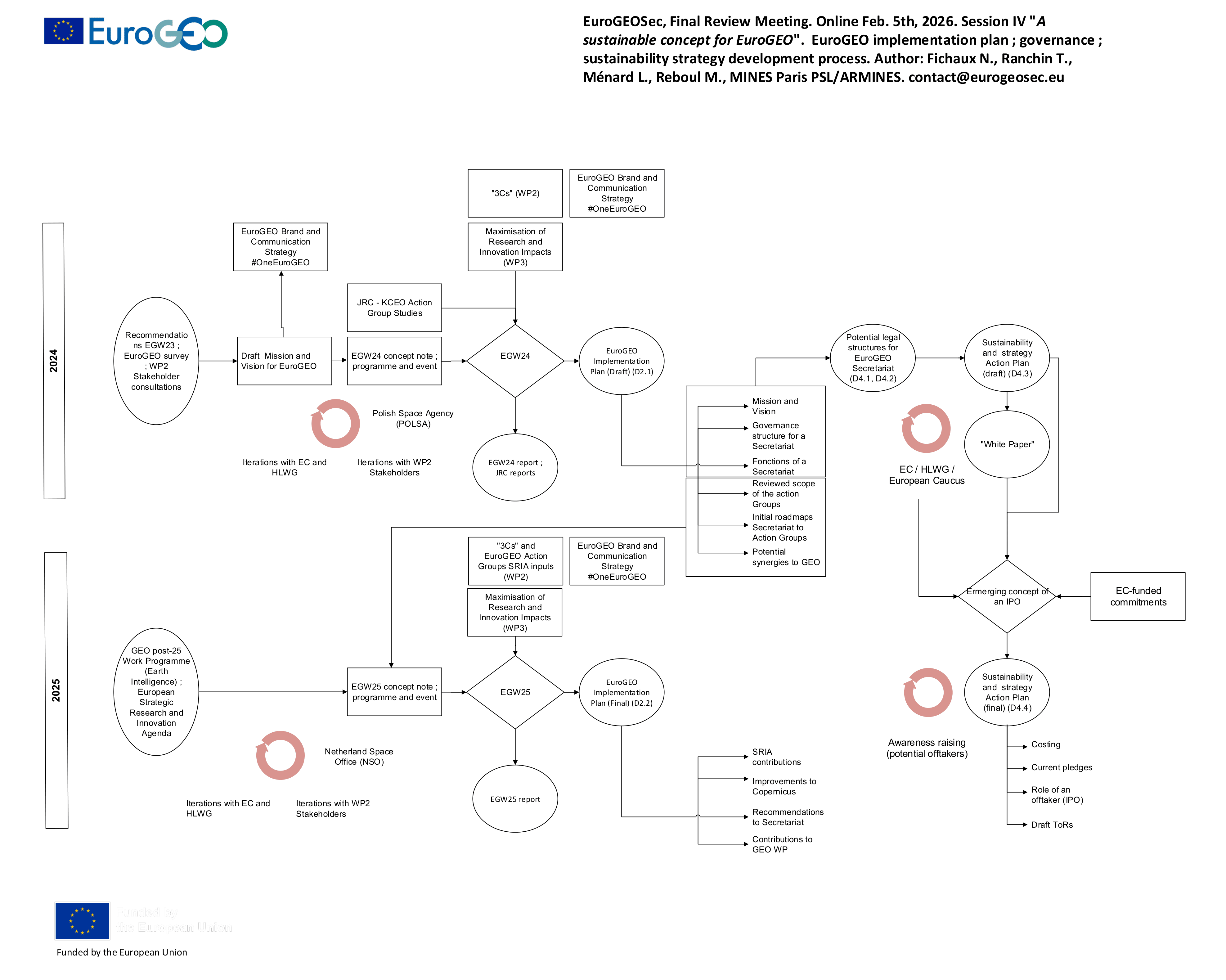
A Sustainable Concept for EuroGEO
click for more
click for more
.png)

is a private non-profit research and technological organisation (RTO) funded in 1967 at the instigation of its partner engineering schools, the Ecoles des Mines network. ARMINES currently shares 48 Joint Research Units with its partner schools, where each legal entity, either private or public, provides personnel, investment and operating resources for common research purposes. In the context of the EuroGEO Secretariat, ARMINES serves as the Coordinator of the project, as well as carries out an in-depth investigation resulting into a sustainability plan offering options for the long-term operationalisation and sustainability of the EuroGEO initiative.

Ecole Nationale Supérieure des Mines de Paris, is one of the oldest French higher education institutions in engineering. The School is a leader in many areas, among which five major fields: Earth sciences and the environment, Energy and process engineering, Mechanical engineering and materials, Mathematics and systems and, Economics, management and society. MINES Paris PSL is a founding member of ARMINES, and they both are gathering public and private personnel and means, to perform research contractual activities and academic research training.
EARSC, the European Association of Remote Sensing Companies, is a membership-based, not for profit organization which coordinates and promotes the activities of European companies engaged in delivering Earth Observation-derived geo-information services. EARSC represents this sector in its broadest sense, creating a network between industry, decision makers and users and covering the full EO value chain from data acquisition through processing, fusion, analysis to final geo-information products & services. In the context of the EuroGEO Secretariat, EARSC undertakes the liaison with the industry as well as sets up clear processes for the provision of support to market development through the Secretariat.

The National Research Council, is the largest public research institution in Italy performing multidisciplinary activities. Founded in 1923, CNR’s mission is to perform research in its own Institutes, to promote innovation and competitiveness of the national industrial system, to promote the internationalization of the national research system, to provide technologies and solutions to emerging public and private needs, to advice Government and other public bodies, and to contribute to the qualification of human resources. In the context of the EuroGEO Secretariat, CNR’s key role is to explore all possible liaisons with partnerships, scientific networks and projects.

National Observatory of Athens, and more specifically, BEYOND Center of Institute for Astronomy, Astrophysics, Space Applications and Remote Sensing, develops research and supports the role, as well as the mandate of civil protection, locally and internationally, with a focus on mitigation, preparedness, response and recovery by delivering accurate information through Earth Observation. In the context of the EuroGEO Secretariat, NOA is in charge of Communication and Dissemination, as well as coordinates support to EuroGEO's governance bodies and structures, e.g. action groups, HLWG, national GEOs etc.

Evenflow is a fast-growing Brussels-based SME specialised in the promotion, exploitation and market uptake of innovative technologies including EO and GNSS. We offer independent consulting services supporting innovation, communication and strategic decision-making. Our role in the EuroGEO Secretariat is the definition, set up and testing of mechanisms that support maximising the impact of EO R&I activities.

Open Geospatial Consortium, is a consortium of experts committed to improving access to geospatial, or location information. The main goal is to connect people, communities, and technology to solve global challenges and address everyday needs. In the context of the EuroGEO Secretariat, OGCE undertakes the role of liaising and creating synergies with the infrastructures relevant to EuroGEO.